All widgets
Planes Overhead
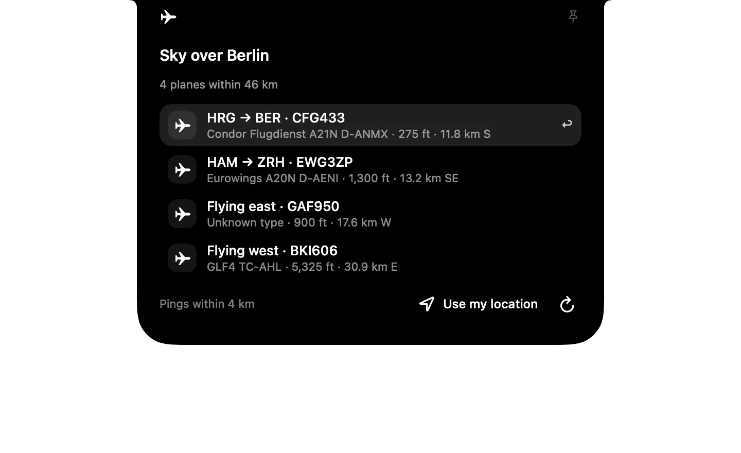
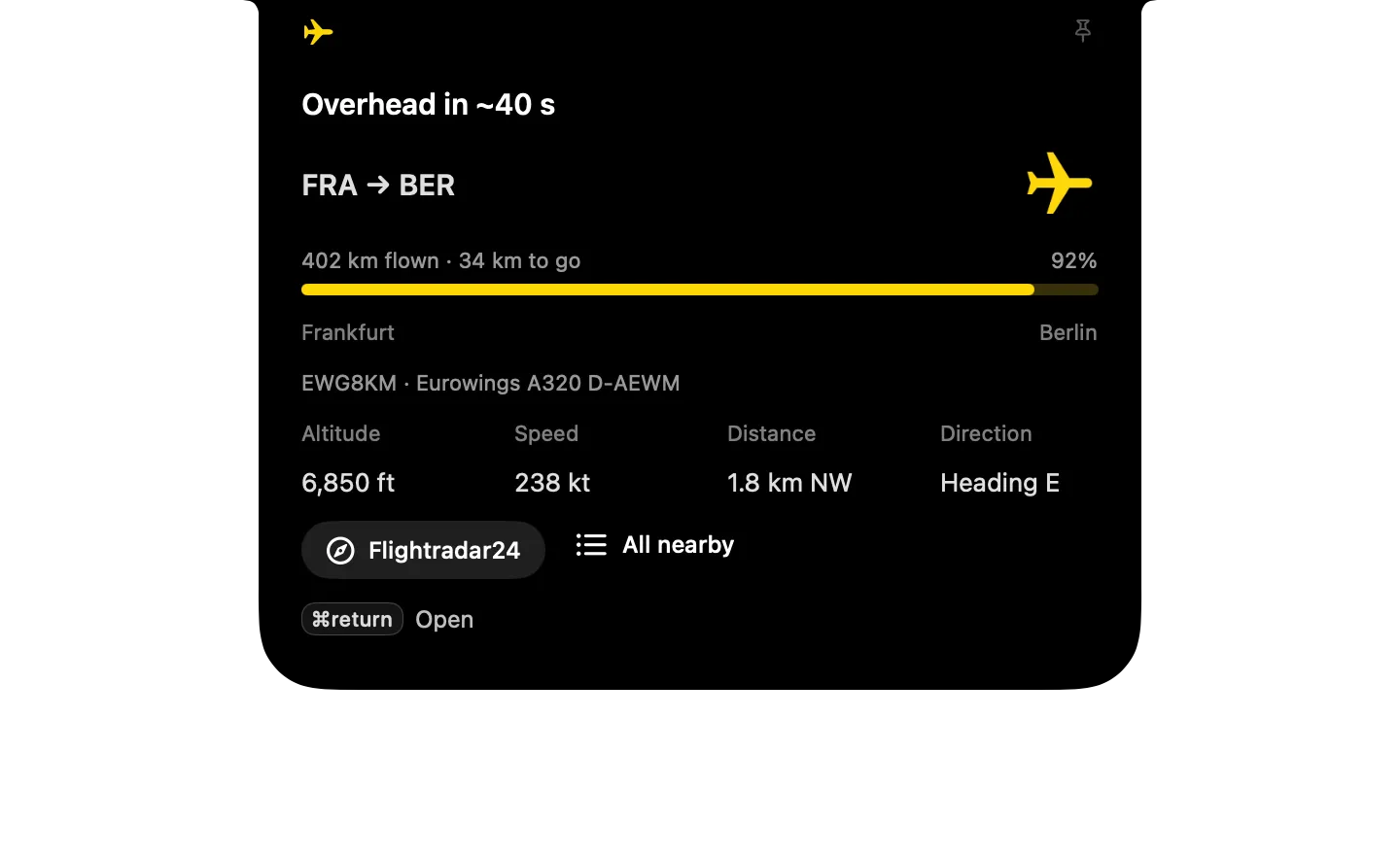
Live planes around your location from ADS-B data, with where each flight is coming from and going to, popping up when one is about to pass overhead.
Chopstick shows you everything in it before installing, and it starts turned off. Or download the .zip to import it yourself.


Type it in the notch's search
- Planes nearby
- Watch sky at lat, lon
- Planes: use my location
- Ping for planes within km km
What it runs
A widget is a folder of plain files. Here is all of its code.
widget.json
{
  "id": "planes-overhead", "icon": "icon-red-airplane.png",
  "name": "Planes Overhead",
  "description": "Live planes around your location from ADS-B data, with where each flight is coming from and going to, popping up when one is about to pass overhead.",
  "anytime": true,
  "initial": "nearby",
  "watch": [
    {
      "script": "sky.sh",
      "every": 60,
      "as": "sky"
    }
  ],
  "triggers": [
    {
      "when": {
        "sky.overhead": true
      },
      "open": "overhead"
    }
  ],
  "states": {
    "nearby": {
      "compact": {
        "leading": {
          "symbol": "airplane"
        },
        "trailing": {
          "text": "{{sky.count | –}}"
        }
      },
      "expanded": {
        "size": "regular",
        "header": {
          "symbol": "airplane",
          "title": "Sky over {{sky.place | your location}}"
        },
        "blocks": [
          {
            "text": "{{sky.summary | Looking for planes…}}",
            "style": "caption"
          },
          {
            "list": {
              "from": "sky.nearby",
              "limit": 5,
              "symbol": "airplane",
              "title": "{{item.route}} · {{item.callsign}}",
              "subtitle": "{{item.desc | Unknown type}} · {{item.alt}} · {{item.dist}}",
              "do": [
                {
                  "open_url": "{{item.url}}"
                }
              ]
            }
          },
          {
            "row": [
              {
                "note": "Pings within {{sky.radius_km | 4}} km"
              },
              "spacer",
              {
                "button": {
                  "symbol": "location",
                  "label": "Use my location",
                  "style": "plain",
                  "do": [
                    {
                      "set": {
                        "new_lat": "",
                        "new_lon": "",
                        "new_radius": ""
                      }
                    },
                    {
                      "run": "set_location.sh"
                    },
                    {
                      "refresh": "sky"
                    }
                  ]
                }
              },
              {
                "button": {
                  "symbol": "arrow.clockwise",
                  "style": "plain",
                  "do": [
                    {
                      "refresh": "sky"
                    }
                  ]
                }
              }
            ],
            "align": "center"
          }
        ]
      }
    },
    "overhead": {
      "task": true,
      "open": true,
      "dismiss_after": 30,
      "compact": {
        "leading": {
          "symbol": "airplane",
          "tint": "yellow"
        },
        "trailing": {
          "text": "{{sky.plane.callsign | Overhead}}"
        }
      },
      "expanded": {
        "size": "regular",
        "header": {
          "symbol": "airplane",
          "tint": "yellow",
          "title": "{{sky.plane.when | Plane overhead}}"
        },
        "blocks": [
          {
            "row": [
              {
                "text": "{{sky.plane.route | Route unknown}}",
                "style": "title"
              },
              {
                "image": "plane-yellow.png",
                "size": "small"
              }
            ],
            "align": "center"
          },
          {
            "progress": {
              "value": "{{sky.plane.progress | 0.5}}",
              "max": "1",
              "label": "{{sky.plane.trip | Route not published}}",
              "tint": "yellow"
            }
          },
          {
            "row": [
              {
                "note": "{{sky.plane.from_city | Origin unknown}}"
              },
              "spacer",
              {
                "note": "{{sky.plane.to_city | Destination unknown}}"
              }
            ]
          },
          {
            "text": "{{sky.plane.callsign | Unknown flight}} · {{sky.plane.desc | Unknown type}}",
            "style": "caption",
            "lines": 1
          },
          {
            "row": [
              {
                "stack": [
                  {
                    "note": "Altitude"
                  },
                  {
                    "text": "{{sky.plane.alt | –}}"
                  }
                ]
              },
              "spacer",
              {
                "stack": [
                  {
                    "note": "Speed"
                  },
                  {
                    "text": "{{sky.plane.speed | –}}"
                  }
                ]
              },
              "spacer",
              {
                "stack": [
                  {
                    "note": "Distance"
                  },
                  {
                    "text": "{{sky.plane.dist | –}}"
                  }
                ]
              },
              "spacer",
              {
                "stack": [
                  {
                    "note": "Direction"
                  },
                  {
                    "text": "{{sky.plane.heading | –}}"
                  }
                ]
              }
            ]
          },
          {
            "row": [
              {
                "button": {
                  "symbol": "safari",
                  "label": "Flightradar24",
                  "style": "filled",
                  "do": [
                    {
                      "open_url": "{{sky.plane.url}}"
                    }
                  ]
                }
              },
              {
                "button": {
                  "symbol": "list.bullet",
                  "label": "All nearby",
                  "style": "plain",
                  "do": [
                    {
                      "go": "nearby"
                    }
                  ]
                }
              },
              "spacer"
            ]
          }
        ]
      },
      "keys": [
        {
          "key": "cmd+return",
          "label": "Open",
          "do": [
            {
              "open_url": "{{sky.plane.url}}"
            }
          ]
        }
      ]
    }
  },
  "commands": {
    "show": {
      "description": "Show the planes around you right now.",
      "phrase": "Planes nearby",
      "do": [
        {
          "refresh": "sky"
        },
        {
          "go": "nearby"
        }
      ]
    },
    "refresh": {
      "description": "Fetch the latest flight positions.",
      "do": [
        {
          "refresh": "sky"
        }
      ]
    },
    "set_location": {
      "description": "Watch the sky at a specific latitude/longitude instead of your IP-based location.",
      "phrase": "Watch sky at {lat}, {lon}",
      "inputs": {
        "lat": {
          "type": "number",
          "description": "Latitude in degrees"
        },
        "lon": {
          "type": "number",
          "description": "Longitude in degrees"
        }
      },
      "do": [
        {
          "set": {
            "new_lat": "{{input.lat}}",
            "new_lon": "{{input.lon}}",
            "new_radius": ""
          }
        },
        {
          "run": "set_location.sh"
        },
        {
          "refresh": "sky"
        },
        {
          "go": "nearby"
        }
      ]
    },
    "use_my_location": {
      "description": "Go back to guessing your location from your IP address.",
      "phrase": "Planes: use my location",
      "do": [
        {
          "set": {
            "new_lat": "",
            "new_lon": "",
            "new_radius": ""
          }
        },
        {
          "run": "set_location.sh"
        },
        {
          "refresh": "sky"
        },
        {
          "go": "nearby"
        }
      ]
    },
    "set_radius": {
      "description": "Set how close (in km) a plane must be to count as overhead and pop up.",
      "phrase": "Ping for planes within {km} km",
      "inputs": {
        "km": {
          "type": "number",
          "description": "Radius in kilometres"
        }
      },
      "do": [
        {
          "set": {
            "new_lat": "",
            "new_lon": "",
            "new_radius": "{{input.km}}"
          }
        },
        {
          "run": "set_location.sh"
        },
        {
          "refresh": "sky"
        },
        {
          "go": "nearby"
        }
      ]
    }
  },
  "preview": {
    "states": [
      "nearby",
      "overhead"
    ],
    "data": {
      "sky": {
        "place": "Berlin",
        "radius_km": 4,
        "count": 3,
        "overhead": true,
        "summary": "3 planes within 46 km",
        "plane": {
          "callsign": "EWG8KM",
          "type": "A320",
          "reg": "D-AEWM",
          "alt": "6,850 ft",
          "speed": "238 kt",
          "dist": "1.8 km NW",
          "when": "Overhead in ~40 s",
          "url": "https://www.flightradar24.com/EWG8KM",
          "from": "FRA",
          "from_city": "Frankfurt",
          "to": "BER",
          "to_city": "Berlin",
          "airline": "Eurowings",
          "route": "FRA → BER",
          "progress": 0.92,
          "heading": "Heading E",
          "trip": "402 km flown · 34 km to go",
          "desc": "Eurowings A320 D-AEWM"
        },
        "nearby": [
          {
            "callsign": "EWG8KM",
            "type": "A320",
            "alt": "6,850 ft",
            "speed": "238 kt",
            "dist": "1.8 km NW",
            "when": "Overhead in ~40 s",
            "url": "https://www.flightradar24.com/EWG8KM",
            "route": "FRA → BER",
            "airline": "Eurowings",
            "desc": "Eurowings A320 D-AEWM"
          },
          {
            "callsign": "RYR4TB",
            "type": "B38M",
            "alt": "12,300 ft",
            "speed": "301 kt",
            "dist": "14.2 km S",
            "url": "https://www.flightradar24.com/RYR4TB",
            "route": "BER → STN",
            "airline": "Ryanair",
            "desc": "Ryanair B38M"
          },
          {
            "callsign": "KLM73D",
            "type": "B738",
            "alt": "39,000 ft",
            "speed": "460 kt",
            "dist": "38.5 km E",
            "url": "https://www.flightradar24.com/KLM73D",
            "route": "Flying east",
            "desc": "B738"
          }
        ]
      }
    }
  }
}
set_location.sh
# Save the spot to watch: CHOPSTICK_NEW_LAT / CHOPSTICK_NEW_LON (empty = guess from IP),
# CHOPSTICK_NEW_RADIUS in km (empty = keep).
store="$CHOPSTICK_STORAGE"; mkdir -p "$store"; loc="$store/location.json"
[ -s "$loc" ] || echo '{"radius_km":4}' > "$loc"
if [ -n "$CHOPSTICK_NEW_LAT" ] && [ -n "$CHOPSTICK_NEW_LON" ]; then
  /usr/bin/jq -c --argjson a "$CHOPSTICK_NEW_LAT" --argjson o "$CHOPSTICK_NEW_LON" '.lat=$a | .lon=$o | .place="Custom spot"' "$loc" > "$loc.tmp" || { echo "Latitude/longitude must be numbers" >&2; exit 1; }
  mv "$loc.tmp" "$loc"
elif [ "$CHOPSTICK_NEW_LAT" = "" ] && [ -z "$CHOPSTICK_NEW_RADIUS" ]; then
  geo=$(curl -s -m 8 "http://ip-api.com/json/?fields=lat,lon,city")
  echo "$geo" | /usr/bin/jq -e '.lat' >/dev/null 2>&1 || { echo "Couldn't find your location" >&2; exit 1; }
  /usr/bin/jq -c --argjson g "$geo" '.lat=$g.lat | .lon=$g.lon | .place=($g.city // "Here")' "$loc" > "$loc.tmp" && mv "$loc.tmp" "$loc"
fi
if [ -n "$CHOPSTICK_NEW_RADIUS" ]; then
  /usr/bin/jq -c --argjson r "$CHOPSTICK_NEW_RADIUS" '.radius_km=$r' "$loc" > "$loc.tmp" || { echo "Radius must be a number" >&2; exit 1; }
  mv "$loc.tmp" "$loc"
fi
exit 0
sky.sh
# Planes around the saved location, from adsb.lol (falls back to airplanes.live).
# Location lives in $CHOPSTICK_STORAGE/location.json; first run guesses it from the IP.
store="${CHOPSTICK_STORAGE:-$CHOPSTICK_TMP}"
loc="$store/location.json"
[ -n "$store" ] && mkdir -p "$store"

if [ ! -s "$loc" ]; then
  geo=$(curl -s -m 8 "http://ip-api.com/json/?fields=lat,lon,city")
  echo "$geo" | /usr/bin/jq -e '.lat' >/dev/null 2>&1 || { echo '{"error":"No location yet","summary":"Location not found","overhead":false,"count":0,"nearby":[]}'; exit 0; }
  echo "$geo" | /usr/bin/jq -c '{lat, lon, place: (.city // "Here"), radius_km: 4}' > "$loc"
fi

lat=$(/usr/bin/jq -r '.lat' "$loc")
lon=$(/usr/bin/jq -r '.lon' "$loc")

feed=$(curl -s -m 10 "https://api.adsb.lol/v2/point/$lat/$lon/25")
echo "$feed" | /usr/bin/jq -e '.ac' >/dev/null 2>&1 || feed=$(curl -s -m 10 "https://api.airplanes.live/v2/point/$lat/$lon/25")
echo "$feed" | /usr/bin/jq -e '.ac' >/dev/null 2>&1 || { /usr/bin/jq -c '. + {error: "Flight feed unreachable", summary: "Flight feed unreachable", overhead: false, count: 0, nearby: []}' "$loc"; exit 0; }

base=$(echo "$feed" | /usr/bin/jq -c --slurpfile l "$loc" '
  ($l[0]) as $loc |
  def comma: tostring | [scan("\\d")] | reverse | [range(0; length; 3) as $i | .[$i:$i+3] | reverse | join("")] | reverse | join(",");
  def compass: ["N","NE","E","SE","S","SW","W","NW"][((. + 22.5) / 45 | floor) % 8];
  [ .ac[]
    | select((.alt_baro | type) == "number" and .lat != null)
    | (.flight // "" | gsub(" "; "")) as $cs
    | ((.dst // 0) * 1.852) as $km
    # Closest approach in the next 90 s (until the next poll), from track and ground speed.
    | ((.dir // 0) * 3.14159265 / 180) as $b | ((.track // 0) * 3.14159265 / 180) as $t
    | ($km * ($b | sin)) as $px | ($km * ($b | cos)) as $py
    | ((.gs // 0) * 1.852 / 3600) as $v
    | ($v * ($t | sin)) as $vx | ($v * ($t | cos)) as $vy
    | (if $v > 0 then ([0, ([90, (-($px * $vx + $py * $vy) / ($v * $v))] | min)] | max) else 0 end) as $eta
    | ((($px + $vx * $eta) as $x | ($py + $vy * $eta) as $y | ($x * $x + $y * $y) | sqrt)) as $closest
    | {
        hex, lat, lon,
        heading: (if .track then "Heading \(.track | compass)" else "" end),
        track: (.track // null),
        callsign: (if $cs == "" then (.r // .hex | ascii_upcase) else $cs end),
        type: (.t // "Unknown type"),
        reg: (.r // ""),
        alt_ft: .alt_baro,
        alt: "\(.alt_baro | comma) ft",
        speed: (if .gs then "\(.gs | round) kt" else "–" end),
        km: ($km * 10 | round / 10),
        dist: "\($km * 10 | round / 10) km \((.dir // 0) | compass)",
        closest_km: $closest,
        when: (if $eta < 10 then "Overhead now" else "Overhead in ~\($eta / 10 | round * 10) s" end),
        url: "https://www.flightradar24.com/\(if $cs == "" then (.r // .hex) else $cs end)"
      }
  ] | sort_by(.km) as $planes
  | ($planes | map(select(.closest_km <= ($loc.radius_km // 4))) | sort_by(.closest_km)) as $over
  | {
      place: $loc.place, lat: $loc.lat, lon: $loc.lon, radius_km: ($loc.radius_km // 4),
      count: ($planes | length),
      overhead: (($over | length) > 0),
      plane: ($over[0] // null),
      overhead_id: ($over[0].hex // ""),
      nearest: ($planes[0] // null),
      nearby: $planes[0:6],
      summary: (if ($planes | length) == 0 then "No planes within 46 km"
                else "\($planes | length) plane\(if ($planes | length) == 1 then "" else "s" end) within 46 km" end)
    }')

# Routes (origin → destination) from adsbdb.com, cached per callsign for a day.
routes="$store/routes"; mkdir -p "$routes"
for cs in $(echo "$base" | /usr/bin/jq -r '[.plane.callsign?, .nearby[].callsign] | map(select(. != null)) | unique | .[]'); do
  case "$cs" in *[!A-Za-z0-9]*) continue;; esac
  f="$routes/$cs.json"
  if [ ! -s "$f" ] || [ -n "$(find "$f" -mtime +0 2>/dev/null)" ]; then
    ( r=$(curl -s -m 6 "https://api.adsbdb.com/v0/callsign/$cs"); echo "$r" | /usr/bin/jq -e '.response' >/dev/null 2>&1 && echo "$r" > "$f" ) &
  fi
done
wait

map=$(cd "$routes" && for f in *.json; do [ -s "$f" ] && /usr/bin/jq -c --arg k "${f%.json}" '{($k): .}' "$f" 2>/dev/null; done | /usr/bin/jq -cs 'add // {}')

echo "$base" | /usr/bin/jq -c --argjson routes "${map:-{\}}" '
  def rad: . * 3.14159265 / 180;
  def km($a; $b): (($b[0] - $a[0]) | rad) as $dl | (($b[1] - $a[1]) | rad) as $dn
    | (($dl / 2 | sin) * ($dl / 2 | sin) + ($a[0] | rad | cos) * ($b[0] | rad | cos) * ($dn / 2 | sin) * ($dn / 2 | sin))
    | 12742 * (sqrt | asin);
  def city: (.municipality // .name // "") | split("/")[0] | split(",")[0];
  def code: .iata_code // .icao_code;
  def way: ["north","northeast","east","southeast","south","southwest","west","northwest"][((. + 22.5) / 45 | floor) % 8];
  def desc: [.airline, .type, .reg] | map(select(. != null and . != "")) | join(" ");
  def comma: tostring | [scan("\\d")] | reverse | [range(0; length; 3) as $i | .[$i:$i+3] | reverse | join("")] | reverse | join(",");
  def route:
    if . == null then null
    elif ($routes[.callsign].response | type) == "object" and (
      $routes[.callsign].response.flightroute as $f
      | km([$f.origin.latitude, $f.origin.longitude]; [.lat, .lon]) + km([.lat, .lon]; [$f.destination.latitude, $f.destination.longitude])
        <= km([$f.origin.latitude, $f.origin.longitude]; [$f.destination.latitude, $f.destination.longitude]) * 1.25 + 150) then
      $routes[.callsign].response.flightroute as $f
      | km([$f.origin.latitude, $f.origin.longitude]; [.lat, .lon]) as $done
      | km([.lat, .lon]; [$f.destination.latitude, $f.destination.longitude]) as $left
      | . + {
          from: ($f.origin | code), from_city: ($f.origin | city),
          to: ($f.destination | code), to_city: ($f.destination | city),
          airline: ($f.airline.name // ""),
          route: "\($f.origin | code) → \($f.destination | code)",
          progress: (if ($done + $left) > 0 then ($done / ($done + $left) * 100 | round) / 100 else 0 end),
          trip: "\($done | round | comma) km flown · \($left | round | comma) km to go"
        } | . + { desc: desc }
    elif .track != null then
      . + { route: "Flying \(.track | way)", from_city: "From the \((.track + 180) | way)", to_city: "Toward the \(.track | way)",
            progress: 0.5, trip: "Route not published", desc: desc }
    else . + { route: "Route unknown", trip: "Route not published", desc: desc } end;
  .plane |= route | .nearest |= route | .nearby |= map(route)'